
Southeast Area Plan Update and Draft Recommendations
postedThank you to everyone who has participated in the Southeast Area Plan process so far! Thanks especially those residents who have engaged who live in the Rolling Meadows, Heistand Park, or Heritage Heights neighborhoods that are both in the Southeast planning area and in District 3.

Public Engagement So Far
The Southeast Area Plan process has gathered public input in a variety of ways:
- Multiple in-person open house meetings and corresponding virtual informational meetings
- An online comment maps
- The high-participation Madison Madness bracket last spring
- Several visits to neighborhood association meetings and parent-teacher organization events, including several that I have attedned
- Collaborating with La Follette High School students participating in the UW PEOPLE program
- Partnership with the nINA Collective to host focus group meetings
- Pop-up outreach at Pinney Library, community events, and Bike to Work Week
- A neighborhood walk and a business walk, both right here in District 3
- Various City legislative committee check-ins in 2025
- Two very fun and well-attended basketball court painting events with dozens of kids and families in the Hiestand Park neighborhood, this Area Plan’s Community Action Strategy area based on poverty and demographic data from the U.S. Census
Project Phase
City Staff will soon prepare the draft Southeast Area Plan document for introduction through the City’s legislative process for adoption this coming spring. As they prepare for drafting, they’re asking City committees for feedback on the proposed draft recommendations based on public input.
The Southeast area plan was at Transportation Commission on Dec 3 for feedback on the transportation-related items and went to Board of Park Commissioners on Dec 10 for feedback on the Parks-related recommendations. This coming week, the Plan goes to Plan Commission (here's the staff presentation) on Monday for feedback on land uses and to the Economic Development Committee on Wednesday for input on the Economy and Opportunity recommendations.
The SEAP team will use this feedback to prepare the plan document that will be introduced for the legislative adoption process. The Southwest Area Plan process is happening at the same time; here's a link to that project page for those who are interested.
Draft Plan Recommendations
This interactive storymap provides a summary of draft plan recommendations so far - I highly recommend checking it out! This document provides the full, detailed list of these recommendations.
Here are some key items in the draft recommendations from Planning staff related to District 3, organized by Plan chapter.

- Land use:
- Proposes changes land uses that would allow redevelopment and revitalization along transit corridors, including Milwaukee Street and Cottage Grove Road. Note that the purple categories are mixed-use, meaning they would allow property owners to add neighborhood-serving land uses like businesses, retail, or restaurants.
- Proposes two potential to guide the eventual redevelopment of the 41-acre former American Family Insurance site on North Walbridge (privately owned), depending on whether the existing office building is retained or replaced as part of redevelopment.
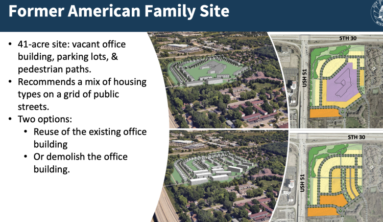 Image credit: City Planning - SEAP Planning Team
Two potential site concepts for the old American Family office building and site (privately-owned). The one on top applies if it's redeveloped while reusing the existing building; the version on bottom is how this might look if the existing building is removed as part of redevelopment. - Proposes a potential site plan for the former Karmenta site at Milwaukee/Milo currently home to the The Salvation Army’s temporary family shelter (City-owned).
 Image credit: City Planning - SEAP Planning Team
Potential site layout at the City-owned former Karmenta Site on Milwaukee Street and Milo Lane, currently occupied by the temporary Salvation Army family shelter. 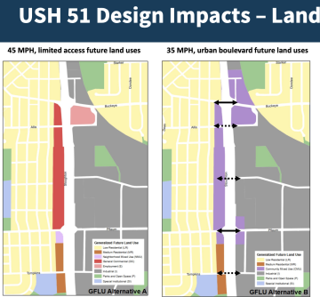 Image credit: City Planning - SEAP Planning Team
The left image (similar to existing uses) will likely remain if WisDOT keeps a high-speed highway-like roadway; the right-hand image with mixed-uses and better connectivity if WisDOT chooses a lower-speed future roadway.
- Transportation:
- The most consequential transportation item in the Southeast area is working with WisDOT to guide their South Stoughton Road corridor study plans, hoping for an eventual plan there that enables improved connectivity, safer crossings, and more neighborhood-friendly land uses along Stoughton Road.
- Consider a North-South Metro Transit route that connects to LaFollette High School and employment centers east of Hwy 51 if the Wide Boulevard or other urban cross section Roadway is chosen as the new design for Hwy 51.
- Identifies sites in the High Injury Network and where intersection improvements are needed, including on Milwaukee Street, North Thompson Drive, Swanton Road, Cottage Grove Road, and Acewood Blvd.
-
 Image credit: City Planning - SEAP Planning Team
- Neighborhoods and Housing: incentivize affordable housing at varied levels of Area Median Income (AMI), particularly on the commercial corridors of Milwaukee Street, Cottage Grove Road, Atwood/Monona Drive through the Affordable Housing Fund, City’s Land Banking Program, and Tax Increment Financing.
- Economy and Opportunity: revitalize commercial corridors and explore business partnerships and potentially a new Tax Increment Finance district in the Southeast business park to expand access to the Small Cap TIF Business Loan Program.
- Culture and Character: due to the lack of “Third Spaces”, the City Parks Division and Madison Public Library should encourage local community partners such as the YMCA, MSCR, and Neighborhood Organizations to consider placemaking and programming opportunities.
- Green and Resilient: develop a master plan for Hiestand Park (which doesn’t have one, but has parcels nearby that could redevelop in the not-too-distant future) along with the smaller neighborhood parks and mini parks.
- Effective Government: Work with the applicable school districts to address pedestrian, bicycle, and traffic safety issues around schools when street repaving, reconstruction, or other changes to the right-of-way are being considered. Improvements may include signage, increasing crosswalk visibility, modifying traffic patterns, increasing nearby sidewalk connectivity, and implementing safe all-ages-and-abilities bicycle connections.
- Health and Safety:
- Conduct Vision Zero speed analyses, enforce traffic regulations and explore traffic calming improvements like road diets, speed bumps and other measures along major streets.
- Improve the safety of pedestrian crossings along major arterials by adding bump outs, continental crosswalks and Rapid Flashing Beacons.
More information about the Southeast Area Plan is available on its project website.
Additional comments, suggestions, or questions at this point can be sent to: southeastareaplan@cityofmadison.com.
