
Legislative Approval Process Begins for Southeast Area Plan
postedThank you to everyone who has participated in the Southeast Area Plan process so far! Thanks especially those in the Rolling Meadows, Hiestand, and Heritage Heights neighborhoods that are both in the Southeast planning area and in District 3.
The Tuesday, May 5th Common Council agenda includes an item introducing the legislation to adopt the Southeast Area Plan and make the corresponding updates to the Madison Comprehensive Plan. The draft Plan includes several chapters of recommendations within the Southeast Area, more on that below. Several City committees will review the draft Plan in the coming weeks and have an opportunity to make recommendations to the Common Council (adoption, amendments, etc.).
This post provides background information about the draft Plan with a focus on District 3 and describes the next steps in the legislative process, including opportunities for residents to weigh in.

Background Information
The City's Area Plans are a tool to guide changes that occur over time to our community, such as land use, housing, transit, streets, bike paths, and other community facilities, all steered by City policies and resident feedback. The Southeast Area Plan will cover the Rolling Meadows, Hiestand, and Heritage Heights neighborhoods within District 3.
Area plans contain recommendations that reflect local needs based on public input (link to public feedback summaries). The Southeast Area Plan's public-facing process began in late 2024 and has involved a great many channels for input including:
- Open-house meetings with presentations
- Presentations to neighborhood meetings and PTO meetings
- Tabling at neighborhood events
- Resident surveys
- A high-participation Madison Madness ranking bracket
- An online commenting map
- Focus groups
- A business walk and neighborhood walk
- Public hearings and discussions at several City committees
At each point in this year and a half-long process, City Planning staff have collected a ton of input about residents' needs, concerns, and favorite features of Southeast Side neighborhoods. In recent months, the Southeast Area Planning team compiled this input into Plan recommendations as outlined in the draft Plan document.
Draft Plan Recommendations in District 3
The draft Southeast Area Plan is organized into chapters by topic. Here are some draft Plan recommendations relevant to District 3, by Plan chapter, and with pages from the Plan document where you can find more information.
*Please note that the below is my own very brief summary, which doesn't even come close to capturing the tremendous amount of information within the draft plan sections. In addition, these page number references apply to the version of the draft plan as of May 2nd, 2026. Subsequent changes to the plan document may throw off these page references.

- Land Use (begins on page 18)
- Proposes potential housing and mixed-use redevelopment areas, pending those property owners' choices of course, along Milwaukee Street west of Lamplighter and along Cottage Grove Road west of the Heritage-Elvehjem greenway (page 22)
- Proposes potential site plan concepts for the currently-for-sale American Family Insurance site at the southeast corner of Stoughton Road and Hwy 30 (page 26)
- Proposes potential site redevelopment plan concept for the City-owned Karmenta site on Milwaukee Street, currently home to the temporary Salvation Army Family Shelter, I pushed for this recommendation (page 28)
- Transportation (page 33)
- Identifies a gap in north/south transit service in neighborhoods between Stoughton Road and the Interstate (page 36)
- Maps existing and planned shared-use path and bike routes (page 37)
- Shows the City's desired outcome from WisDOT's ongoing Stoughton Road redesign project, with lower speeds and safer crossings (page 42)
- Neighborhoods and Housing (page 47)
- Identifying the need for more “complete neighborhoods" in the southeast area, where many areas are currently housing-only (page 49)
- Describes residents' desire for more affordable housing options and more options for housing types, based on public input (page 51)
- Describes community members' desire to see more support and resources for Madison residents who are unhoused, including concerns about the conditions at encampments in the area and the need for a “strong system for housing people in ways that meet their needs and work toward permanent housing opportunities" (page 51)
- Recommends working with community stakeholders to locate a community center in the Southeast area when/if: “existing community buildings, such as the Eastmorland Community Center and MMSD schools, are not adequate to meet community needs for programming" and “community support for a center is demonstrated through organization around fundraising for center construction and operations." I pushed for this one, too (page 53)
- Economy and Opportunity (page 54) – this section identifies the Southeast Area as a hub for Madison's business, commerce, and jobs, and mostly discusses commercial and industrial areas and potential TID areas outside of District 3
- Culture and Character (page 66) – this section describes residents' love for places like Pinney Library and neighborhood parks, and the strong desire for more places and events where people can come together, with general recommendations aligned with this goal (page 73)
Green and Resilient (page 74)
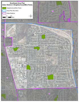 Image credit: Madison Parks
Map of the five District 3 parks getting new Park Development Plans this year as part of the Southeast Area Plan process. Public input for these park plans is ingoing; we'll see those later this summer. - Highlights the Southeast Area's excellent coverage of parkland (434 acres), stormwater greenways (422 acres), and tree canopy (pages 76-78)
- Recommends completion and implementation of Park Development Plans in mini parks and neighborhood parks, including Honeysuckle, Portland, McGinnis, Onyx, and Heritage Parks in District 3 (page 80)
- Recommends that the City “develop an updated Master Plan for Hiestand Park that addresses the current and future needs of the surrounding community and park visitors." I pushed for this one, too (page 80)
- Effective Government (page 82) -- Describes available water and sanitary sewer service and shows areas of Blooming Grove that will join Madison in 2027 (page 82)
- Health and Safety (page 87)
- Provides public safety (calls and offenses data), education demographics data, and health outcomes data (page 87)
- Identifies actions to address speeding and pedestrian safety along several streets including Milwaukee, Cottage Grove Road, Swanton, North Thompson, and Atlas (page 90)
- Recommends that the City “work with resident leaders to continue to monitor environmental factors that may contribute to, or protect against violence (e.g. dimly lit areas, abandoned buildings, etc.) and use violence prevention resources such as the Madison & Dane County Violence Prevention: A Roadmap to Reducing Violence Report to address related issues" and “continue educating neighborhoods on the importance of crime prevention including locking car doors, monitoring their own speeding habits, etc." (page 92)
- Recommends the City “work with MMSD to determine whether students living north of Milwaukee Street could qualify for busing to Kennedy and Schenk Elementary schools due to traffic safety concerns along Milwaukee St" (page 92)
- Community Action Strategy—Hiestand (page 94) – this section identifies areas where more than half the population is living with low to moderate incomes (using U.S. Housing and Urban Development definitions) and includes recommendations for how to use federal Community Development Block Grant funds to support this population. Hiestand, within District 3, is the Southeast Area's only qualifying “Community Action Strategy" neighborhood. The objectives of this program are to build local community capacity, build community and stakeholder relationships, and support small-scale physical improvements. Pages 96 and 97 provide much more information about potential project expenditures and public input that will help to inform how the funds will be used.
Next Steps in the Legislative Process
Following introduction of the draft plan legislation at Council, it will be referred to the following committee meetings for their feedback and recommendations on items in the plan related to their role/purpose. The draft Plan and every committee's input will go back to Council on June 23rd (tentative). Each of these meetings will include a public hearing with an opportunity for residents to share additional input.
SEAP legislative schedule:
- Board of Park Commissioners: May 13
- Urban Design Commission: May 20
- Transportation Commission: June 3
- Community Block Grant Committee: June 4
- Landmarks Commission: June 8
- Plan Commission: June 15
- Common Council – Consider Adoption: June 23
I will write about most of the above meetings in the City Meetings section of future Weekly Updates blog posts. Stay tuned!
Tags:
- Bike/Ped Path,
- Board of Park Commissioners,
- City Planning,
- Common Council,
- Development Proposal,
- Generalized Future Land Use,
- Hiestand Park,
- Madison Parks,
- Plan Commission,
- South Stoughton Road Study,
- Southeast Area Plan,
- Stoughton Road,
- Traffic Engineering,
- Transportation Commission,
- Park Development Plans
