
Flood Warning Signs at E Johnson Street and N Third Street
July 3, 2026 Update
The signs were installed and connected to the flood sensors on 7/2/26. The City and USGS will be troubleshooting the technology during the first few storms to ensure it is working as intended. You can contact Jojo O'Brien at jobrien@cityofmadison.com to share observations.
View past project updates »Project Details
Project Information
Project Overview
In order to enhance public safety, the City is installing experimental flood warning signage to notify the public of flooding at E Johnson St and N Third St. The signs will be installed during the summer of 2026.
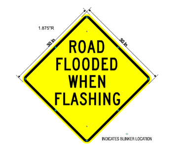
The warning signs read, “road flooded when flashing," and flashers will light up at streets around the intersection when flood sensors indicate the intersection is flooded. Those driving and biking through the intersection are encouraged to find another route when the signs are flashing.
This test project is a collaboration between the City and the United States Geological Survey (USGS).
Area Flood Risk
The intersection of East Johnson St and North Third St floods frequently during heavy rainfall. Cars regularly stall out in the intersection, or, when vehicles successfully pass through the flooded intersection, the waves that are created damage adjacent private property. When this flooding occurs at night, it is extra challenging to discern the depth of flood water, and people may not realize it is dangerous to drive through.
-

Channel 3000 news article reporting on flooded intersection.
-

Resident Flood report 7/2/24.


Flood Study Results
The Engineering Division completed the East Isthmus and Yahara River Watershed Study which developed a stormwater model to quantify the flood risk throughout the isthmus and identify conceptual solutions of what it would take to make the area more flood resilient. The intersection of E Johnson St and N Third St is particularly challenging to mitigate flooding due to the following factors:
- Much of this area is low-lying and was originally filled wetland. During a typical summer, the pipes that carry water away from this area are already half-full of water from the Yahara River before it begins raining.
- The area has high groundwater and greenspaces are not very effective at infiltrating stormwater
The study results show the best way to mitigate flooding in this area is to install very large (dual 5' x 12' box) storm sewer pipes the length of Pennsylvania Ave, from Commercial Ave to the Yahara River. This is estimated to cost $33 million and is cost prohibitive to replace.
To address public safety, the flood warning system was developed as a trial project to try to prevent people from driving through the flooded intersection which puts their vehicles at risk to being damaged, and also adds to the damage of adjacent properties.
This intersection was selected for the experimental signs because it floods deeper than 0.5' in the 50% annual chance storm, it is an arterial street, has previous water rescues documented by the Madison Fire Department, and has the possibility for drivers to safely re-route around the flooding.

Flood Sensor Data
The flood sensor was installed and is managed by the USGS. You can view the flood level data which is transmitted at 5 minute intervals directly at the N 3rd St Storm Sewer E Johnson St monitoring location webpage. Via the monitoring location webpage, people can “Subscribe to WaterAlert" if they would like to receive text alerts when the water crests the street elevation (when the sensor shows water 3.9' deep). You may also view the USGS Flash Flood Dashboard for more real-time information on flood depths and rainfall.
For more information about the USGS's work, please visit Low-Cost Sensor Networks for Pluvial Flash Flood Detection and Early Warning in Urban Areas

Project Updates
July 3, 2026 Update
The signs were installed and connected to the flood sensors on 7/2/26. The City and USGS will be troubleshooting the technology during the first few storms to ensure it is working as intended. You can contact Jojo O'Brien at jobrien@cityofmadison.com to share observations.